
Page 2 - Spec Tech Vol 1 Issue 11
P. 2
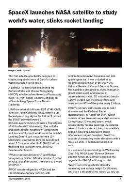
SpaceX launches NASA satellite to study


         world's water, sticks rocket landing


         Image Credit: SpaceX

         The first satellite specifically designed to          contributions from the Canadian and U.K.
         conduct a global survey of Earth's surface            space agencies. It was included as a
         water has taken to the skies.                         recommended mission in the 2007 U.S.
                                                               National Research Council Decadal Survey.
         A SpaceX Falcon 9 rocket launched the
         Surface Water and Ocean Topography                    The satellite is designed to study changes in
         (SWOT) satellite before dawn on Wednesday             global water levels and provide, in
         (Dec. 16) from Space Launch Complex-4E                unprecedented detail, 3D volumetric data for
         at Vandenberg Space Force Base in                     Earth's oceans and millions of lakes and
         California.                                           rivers across 90% of the globe every 21 days.
                                                               SWOT's primary instruments are its nadir
         Liftoff occurred at 6:46 a.m. EST (1146 GMT;
         3:46 a.m. local California time), lightning up        altimeter and the Ka-band Radar
         the early-morning sky as the Falcon 9 carried         Interferometer, or KaRIn for short. KaRIn
         the SWOT payload toward a                             consists of two antennas separated across a
         non-sun-synchronous orbit with a final altitude       33-foot-long (10 meters) boom, which
         of 553 miles (857 kilometers). The rocket's           independently receive readings the satellite
         first stage booster returned to Vandenberg            takes of Earth's surface. Using the satellite's
         and successfully touched down at the facility's       position data and subsequent phase
         Landing Zone-4, just a quarter-mile (0.4              differences in signal reception, SWOT is
         kilometers) downrange from the launch pad,            capable of measuring water elevations with a
         about 7.5 minutes after liftoff. SWOT will be         mere 0.4-inch (1 centimeter) margin of
         deployed into low Earth orbit about 52                error.
         minutes after launch.                                 In a prelaunch press briefing on Wednesday
                                                               (Dec. 14), NASA Earth Science Division
         "What a spectacular launch," said Nadya
         Vinogradova Shiffer, NASA's director of ocean         Director Karen St. Germain explained the
         physics, just after launch. "Welcome to the era       upgrade that SWOT will bring to orbit.
         of SWOT."                                             "We've been doing satellite altimetry
                                                               measuring sea surface height for 30 years,
         SWOT was developed by NASA and the
         French Space Agency (CNES), with                      and that's a big part of the record we rely on


         Space Explorer 2022                                                                                                                                                    2